The science stays. The stack moves.

Geoscience software for foundation GEOINT, safety of navigation, and geomatics, at speed, scale, and precision, from the enterprise cloud to the disconnected edge.

Decades of code. One AI deadline.

Your production workflows still run on scientific code written before the web, on hardware nobody sells anymore. The science inside it is right and irreplaceable. Now the AI pipelines need that output as AI-ready data, on one authoritative geospatial foundation, delivered across security fabrics to analysts at the point of mission need, including sites with austere networking. Rewriting from scratch risks the science. Standing still risks the mission.

Modernize the code. Keep the twelfth decimal.

We build and modernize the geoscience software behind geospatial production: the numerical models and production code that turn measurements into foundation GEOINT, safety-of-navigation products, and the hydrographic science of geomatics. We modernize without changing what it computes, and we deliver the result wherever the analyst is. Identity comes with it: who may see which data, down to the cell, is brokered from your enterprise provider into every map and catalog we build.

Our engineers work in the science, not just around it: Fortran, C++, and Python numerical code, elevation and hydrographic models, and high-performance computing on cloud clusters. We refactor decades-old scientific code (Fortran 77, VB6, and Access) into modern Fortran, C++, Python, and PostGIS and move it from proprietary Unix hardware to x86 Linux, containers, and cloud high-performance computing. AI does the reading and the first draft: agents map the code base, retire what nothing calls, propose the refactor, and document it. A person approves every change, and regression to the twelfth decimal place decides what ships. Not everything has to move at once: where a validated computation is still right, we wrap it as a service so new pipelines and AI workflows call the proven science where they need it, with the same validated results, proven by regression. What this code computes is the foundation GEOINT that downstream geospatial production depends on.

Component-based map visualization on OpenLayers, Cesium, MapLarge, and Esri, REST-configured map services, collaborative GIS portals, base-map and content sustainment, and enterprise file and data delivery, deployed across multiple security fabrics and clouds for analysts wherever they work.

Metadata cataloging and ingest pipelines (NiFi, Kafka, Accumulo) with attribute-based access enforced down to the individual data cell, by clearance, citizenship, and need-to-know, delivered across the air gap into the most secure cloud enclaves.

Mission tooling that keeps working under denied, degraded, intermittent, and limited connectivity, with store-and-forward synchronization so nothing is lost when the link returns. Fielded to forward commands ahead of schedule.

Near-real-time damage assessment from imagery and machine learning within 72 hours of an event, predictive impact-exposure models, automated flood modeling from synthetic-aperture radar, privacy-protecting field imagery, and authoritative datasets published for national reuse.

An automated feature-extraction pipeline we designed and built: segmentation and detection models, conflation against national holdings, vision-language verification, analyst adjudication, persistent entity identifiers, a closed learning loop with a champion gate, and an edge feed measured in kilobytes rather than megabytes. Human insight stays in the loop; machine speed does the rest.

225 modules at a 100% pass rate

Legacy scientific modules refactored for a global intelligence enterprise with no rework and zero production errors, delivered 30 days early and under budget.

Outcomes, measured.

  • Of more than 350 legacy scientific modules, 130 retired through rapid analysis and 225 refactored at a 100% pass rate, with no rework and zero production errors.
  • A 60% execution-speed improvement on a hydrographic elevation model, validated by regression to the twelfth decimal.
  • Nine releases in 16 months of a classification-aware catalog into air-gapped enclaves, with test-finding patches turned around within a week.
  • Damage assessments within 72 hours of an event, flood modeling automated from synthetic-aperture radar, and impact maps used in national leadership briefings.
  • Disconnected-capable mission tooling operational at four combatant commands in under 12 months.

Open standards, on your stack.

Fortran (77 to modern) · C++ · Java · Python · PostgreSQL and PostGIS · AWS ParallelCluster HPC · Docker and Kubernetes · GitLab, Jenkins, SonarQube · Esri and ArcGIS · OpenLayers · Cesium · MapLarge · OGC web services · STAC · NiFi, Kafka, Accumulo · Keycloak · Kong · ELK · ICEYE SAR · NAIP, Sentinel-2, 3DEP imagery · SAM and U-Net · vision-language models · Overture GERS

Discover first. Then move the science.

Every geospatial engagement runs on Start. Ship. Strengthen. It opens with a 30-day structured discovery of the undocumented legacy system, because nobody has the design document and somebody has to read the code. Then we retire the oldest layer first, keep the familiar interface, move the data model underneath, and change the interface last, so users adopt on their schedule and the production line never stops. A gold branch controls every release, regression to the twelfth decimal runs before anything ships, and SAFe release trains carry work through DevOps into operations and sustainment. Where AI helps with code analysis, refactoring, documentation, and schema redesign, a human reviews every change.

Three missions. Same discipline.

Three missions, told in full on Insights.

Scientific geospatial production code for a global intelligence enterprise

Of more than 350 legacy modules, rapid analysis retired 130 that no workflow still called.

Read the story

Damage assessments within 72 hours of an event

We deliver damage assessments from imagery and machine learning within 72 hours of an event, automated flood modeling from synthetic-aperture radar, and impact maps used in national leadership briefings.

Read the story

Disconnected-capable GEOINT mission tooling

We built disconnected-capable GEOINT mission tooling that stayed operational under intermittent connectivity and reached…

Read the story

Feature extraction, with the analyst in the loop.

On open data, the champion model in the feature-extraction pipeline we designed and built scored 0.790 correctness and 0.812 completeness against a 0.780 inter-reference ceiling, resolved 87% of features to persistent entity identifiers, and produced a 133 KB edge feed from 151 MB of imagery. Every promotion passes a champion gate. Every feature an analyst rejects trains the next round.
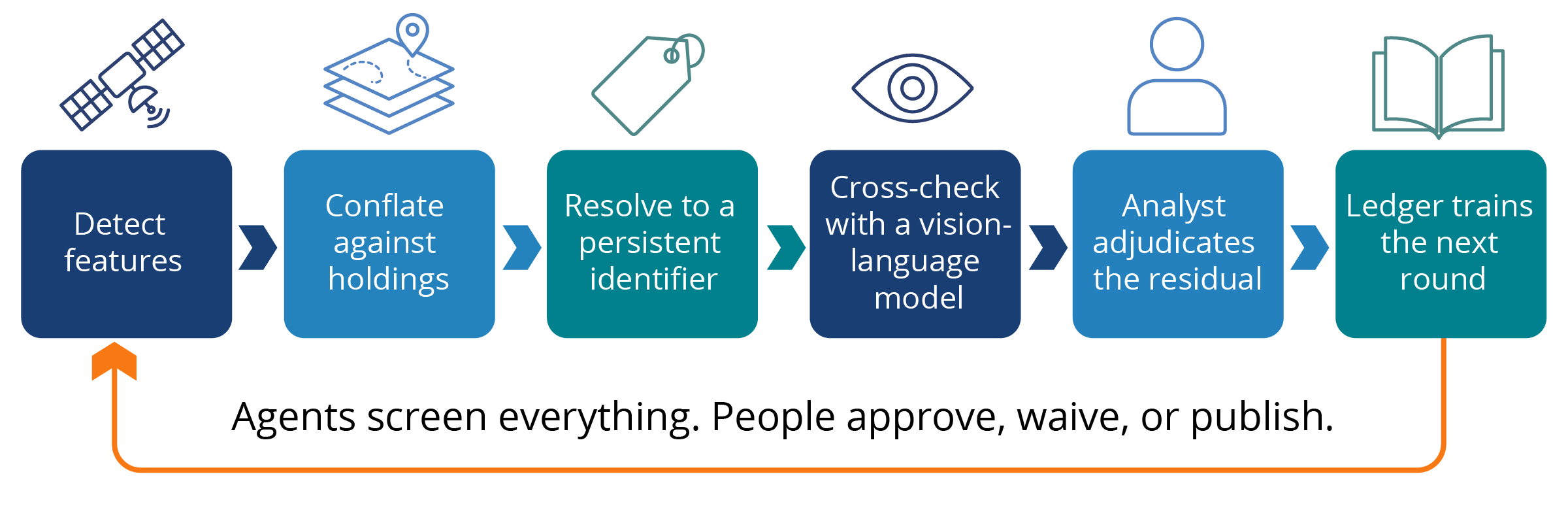
Feature-extraction pipeline: Detect features, Conflate against holdings, Resolve to a persistent identifier, Cross-check with a vision-language model, Analyst adjudicates the residual, Ledger trains the next round. Agents screen everything. People approve, waive, or publish.

Let’s talk geospatial.

Bring the code nobody wants to touch. We will tell you what it takes to move it, and what stays exactly the same.